DANA ISLAND, TURKEY
Ferries from Turkey to Cyprus and smaller vessels use the passage between the island and the mainland.
 |
| West shores of Dana Island |
Did You Know?
Dana Island was the largest shipyard in the ancient world. (more info)
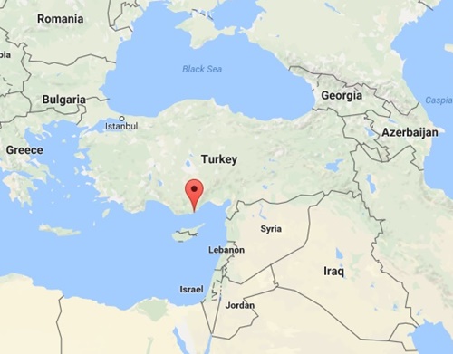
Where is Dana Island?
It's a Turkish island in Mediterranean Sea, It lies in the south coast of Turkey (see map for location)
Other Names of Dana Island
Kargıncık, Pithyussa, Pityusa, (ancient Greek and Latin ), Provençale, Provensale.
Total Area of Dana Island
2.43 km²
It is 2.7 km (1.67 miles) long and 0.9 km (0.55 miles) wide, with a surface area of 2.43 square kilometres (0.93 sq mi)
What Does Dana Island Look Like?
This is a typical Mediterranean island, rocky and full of thorny bushes. There are pine, olive and carob trees on the east and north of the island.
The island is rectangular in shape and mountainous; the highest danaadasi.com peak is 250 metres (820 ft). The water off the north coast of the island has a sandy bottom and is perfect for swimming and snorkelling. However, the east coast is rocky and has sharp cliffs. and is therefore unsuitable for diving or swimming. There is no source of drinking water on the island.
Is It Inhabited?
Nobody lives on the island. It's uninhabited, with no houses or hotels. Construction is definitely not allowed. Animals such as snakes, rabbits, wasps, lizards and birds are the only residents of the island and in winter you may see lots of goats roaming around.
Closest Mainland City
Taşucu ( Silifke )
Distances to/from Dana Island
Historical Ruins on Dana Island
Churches, houses, aqueducts, graves, a Roman bath, harbour and shipyards.
How to Get There
There is no airport or a harbour on the island. You can visit island by daily boat tour from Bogsak or rent a boat from Taşucu or Boğsak for a private tour. Check out the available charters at Tekneveyat
Nobody lives on the island. It's uninhabited, with no houses or hotels. Construction is definitely not allowed. Animals such as snakes, rabbits, wasps, lizards and birds are the only residents of the island and in winter you may see lots of goats roaming around.
Closest Mainland City
Taşucu ( Silifke )
Distances to/from Dana Island
- The distance from the shore is 2.5 km ( 1.34 nautical miles)
- 45 minutes by boat from Boğsak
- 1 hour 15 minutes by boat from Taşucu
- 2.5 hours swimming from the closest shore on the mainland
- 34 minutes by kayak or canoe from the mainland
- 15 minutes by boat and 20 by car from the nearest village (shops)
- 100 km from Girne (Kyrenia), Cyprus ( 54 nautical miles)
Historical Ruins on Dana Island
Churches, houses, aqueducts, graves, a Roman bath, harbour and shipyards.
How to Get There
There is no airport or a harbour on the island. You can visit island by daily boat tour from Bogsak or rent a boat from Taşucu or Boğsak for a private tour. Check out the available charters at Tekneveyat


Yorumlar
Yorum Gönder